
Distance 6 miles (9.7km)
Classification Moderate
Duration 3 hours
Begins Porthclais harbour
OS grid reference SM741242
Walk in a nutshell
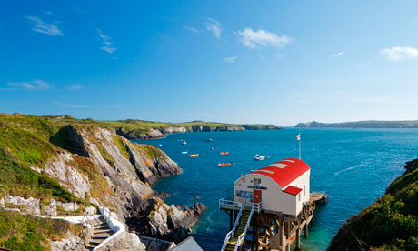
A circular ramble that starts at the miniature Porthclais harbour and crosses the St David's peninsula to arrive at the lifeboat station St Justinian. It then follows the Pembrokeshire Coast Path all the way back to Porthclais, with views over to Ramsey Island.
Why it's special
This route takes you over the oldest rocks in Wales, making it not so much a historic walk as a prehistoric one. The rocks were formed between 542 and 460 million years ago, and are volcanic in origin.
Keep your eyes peeled for
Porthclais harbour – a popular climbing spot for those wishing to take on the cliffs and slabs to the east of the harbour entrance. Tradition has it that St David – reputedly born just along the coast at St Non's chapel – was baptised at Porthclais. In the summer you can take a break here at a kiosk, where a friendly chap called Steve will serve you ice-cream and homemade cake. On the coast path, not long after St Justinian, look out for a small promontory; this is an iron age fort called Castell Heinif. Peer across roughly a mile of sea to Ramsey Island, an RSPB reserve, and on all but the mistiest of days you'll see the isle's twin peaks – the remains of long extinct volcanoes. Meanwhile, just east of Porthlysgi, do stop and admire the picrite headland. Picrite is, of course, a type of basalt, another reminder of the area's volcanic origins.
Recover afterwards
With some hearty fare in the beer garden at the Farmers Arms in St David's. There's an open fire, too, for when the sun has not got his hat on.
If it's tipping down
Make tracks for St David's Cathedral, a place of pilgrimage on the site of a 6th-century monastery. A tour costs £4, booked in advance ().
How to get there
From Haverfordwest railway station, take the 342 or 411 bus to St David's, then nab the Celtic Coaster shuttle bus to Porthclais.
Step by step
1 Turn right as you leave the car park, walking up the road past high blackthorn hedges.
2 At the crossroads turn left (signposted Treginnis). The landscape is dominated by the igneous outcrops of Carn Llidi, Carn Trefeiddan and Penberry. As you pass Treginnis Lodge, Skomer Island comes into view to the south across St Bride's Bay.
3 At the sign for Pencnwc Farm, turn right off the road and immediately left, following the footpath sign to Porthstinian/St Justinian. Walk through a patch of scrub woodland and past a National Trust sign for Treheinif. After about 50m go through a kissing gate and follow bridleway signs around the field edge.
4 Continue to follow the footpath left out of the far corner of the field and then immediately right through a metal gate. Carn Rhosson (topped by a white pole) and the North Bishop come into view as you walk towards the sea and Ramsey Island. Turn right through a metal gate, along a track and through another gate on to the road to St Justinian.
5 Turn left on to the coast path, where you'll remain for the rest of the walk.
6 Continue south through two more kissing gates. After the second, the path bears right past Seal Bay – look out for seal pups in late summer.
7 A steep descent past a short fenced section of cliff brings you to a grassy area and the ruins of a 19th-century copper mine. Follow the coast path south and then east. As you bear left, you can see Skomer, Midland Isle and the Marloes peninsula in the distance.
8 Round the corner you walk through some fine coastal heathland and down to the rocky cove of Porthlysgi. Follow the coast path round to Porthclais harbour and back to the car park.
